 电子书百科大全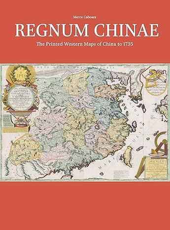
Regnum Chinae: The Printed Western Maps of China to 1735 (Explokart Studies in the History of Cartography, 21)
by: Marco Caboara (Author)
Publisher: Brill Academic Pub
Publication Date: 2022/10/19
Language: English
Print Length: 520 pages
ISBN-10: 9004382038
ISBN-13: 9789004382039
Book Description
Listen to the New Books Network Podcast. The first European map of China faintly relied on the copy of a Chinese original, obtained through bribing and espionage; the last covered in this book was the result of the largest land survey ever made until that time. These two and another 125 maps depict, sometimes uniquely, sometimes copying each other, a country whose images were so different that it was hard to understand which to trust. This study reproduces and describes, for the first time, all the maps of China printed in Europe between 1584 and 1735, unravelling the origin of each individual map, their different printing, issues and publication dates. It also tells, for each, the unique story that made possible these visions from another world, stories marked by scholarly breakthroughs, obsession, missionary zeal, commercial sagacity and greed. For a presentation from the author related to the publication entitled China on Copper Plates: The First 150 Years of Chinese Maps in Western Prints (1584-1735), see: here. A summary: On June 23, 2022, the fourth session of the academic lecture series on "The Weavers of Four-Dimensional Space-Time and Their Creation" on the History of Maps was held in the form of an online seminar at the Kuang-Chi International Scholars Center. Dr. Marco Caboara, an Italian scholar from the Lee Shau Kee Library of Hong Kong University of Science and Technology, gave a lively presentation entitled "China on Copperplate - the First 150 Years of Western Printed Maps of China, 1584-1735". The lecture was conducted in both Chinese and English. Associate Professor Lin Hong from the School of Humanities of Shanghai Normal University served as the moderator and translator. Dr. Yang Xunling, Deputy Director of the Library of Macau University of Science and Technology, served as the main responder. Professor Huang Yijun of Minzu University of China, and Deputy Youth Associate of Fudan University Researcher Ding Yannan, Dr. Catarina Batista and Dr. Ângela Gil from the Library of Macau University of Science and Technology, and Dr. Zheng Man from the Free University of Berlin participated in the discussion. Many domestic and foreign scholars and map enthusiasts listened to the lecture online. The lecture lasted nearly three hours.
About the Author
Listen to the New Books Network Podcast. The first European map of China faintly relied on the copy of a Chinese original, obtained through bribing and espionage; the last covered in this book was the result of the largest land survey ever made until that time. These two and another 125 maps depict, sometimes uniquely, sometimes copying each other, a country whose images were so different that it was hard to understand which to trust. This study reproduces and describes, for the first time, all the maps of China printed in Europe between 1584 and 1735, unravelling the origin of each individual map, their different printing, issues and publication dates. It also tells, for each, the unique story that made possible these visions from another world, stories marked by scholarly breakthroughs, obsession, missionary zeal, commercial sagacity and greed. For a presentation from the author related to the publication entitled China on Copper Plates: The First 150 Years of Chinese Maps in Western Prints (1584-1735), see: here. A summary: On June 23, 2022, the fourth session of the academic lecture series on "The Weavers of Four-Dimensional Space-Time and Their Creation" on the History of Maps was held in the form of an online seminar at the Kuang-Chi International Scholars Center. Dr. Marco Caboara, an Italian scholar from the Lee Shau Kee Library of Hong Kong University of Science and Technology, gave a lively presentation entitled "China on Copperplate - the First 150 Years of Western Printed Maps of China, 1584-1735". The lecture was conducted in both Chinese and English. Associate Professor Lin Hong from the School of Humanities of Shanghai Normal University served as the moderator and translator. Dr. Yang Xunling, Deputy Director of the Library of Macau University of Science and Technology, served as the main responder. Professor Huang Yijun of Minzu University of China, and Deputy Youth Associate of Fudan University Researcher Ding Yannan, Dr. Catarina Batista and Dr. Ângela Gil from the Library of Macau University of Science and Technology, and Dr. Zheng Man from the Free University of Berlin participated in the discussion. Many domestic and foreign scholars and map enthusiasts listened to the lecture online. The lecture lasted nearly three hours. Read more
Regnum Chinae: The Printed Western Maps of China to 1735 (Explokart Studies in the History of Cartography, 21)
未经允许不得转载:电子书百科大全 » Regnum Chinae: The Printed Western Maps of China to 1735 (Explokart Studies in the History of Cartography, 21)
相关推荐
 The History of Anti-Semitism, Volume 3: From Voltaire to Wagner
 International Solidarity in the Low Countries during the Twentieth Century: New Perspectives and Themes
 300 Years of the French in Old Mines: A Narrative History of the Oldest Village in Missouri
 Escape from the Pit: A Woman's Resistance in Nazi-occupied Poland, 1939-1943 (Excelsior Editions)
 Alexandrine Teaching on the Universe (Routledge Revivals)
 Dynamic Repetition: History and Messianism in Modern Jewish Thought (The Tauber Institute Series for the Study of European Jewry)
 The Latin Continuation of William of Tyre (Crusade Texts in Translation)
 Shmuel Hugo Bergmann: A Life between Prague and Jerusalem (Europäisch-jüdische Studien – Beiträge, 63)
评论前必须登录!
立即登录 注册